 Syken metatietopalvelu
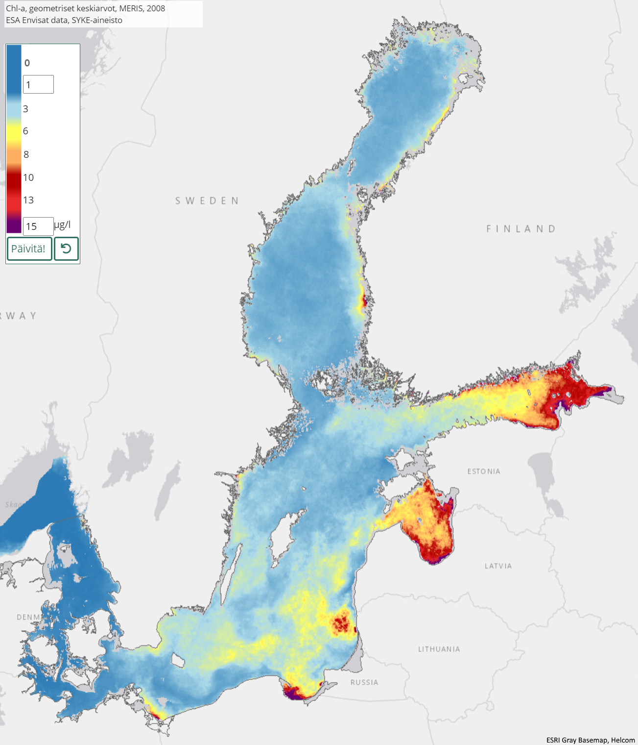
Itämeren vuosittainen a-klorofyllin geometrinen keskiarvo (Envisat MERIS) 2003–2011 / Yearly geometric mean of chlorophyll-a in the Baltic Sea (Envisat MERIS) 2003–2011
[FI] Satelliittihavaintoja käytetään Itämeren pintaveden a-klorofyllin (ug/l) seurantaan sulan veden aikaan huhtikuusta lokakuuhun. A-klorofylli (chl-a) kuvaa levien määrää vedessä, mutta ei suoraan syanobakteerien määrää. Se on myös keskeinen tekijä veden rehevyystason arvioinnissa.
Aineisto edustaa kesän a-klorofyllin vuotuista tasoa kattaen kaikki pilvettömät havainnot kesäkuun alusta syyskuun loppuun. Kausikomposiittiaineisto lasketaan käyttämällä kunkin pikselin kaikkien havaintojen geometrista keskiarvoa, joka kuvaa aineiston jakaumaa tilastollisesti hyvin. Aineiston maastoerotuskyky on 300 m.
a-klorofyllin koosteaineisto on laskettu Sykessä vuosilta 2003–2011 käyttäen Envisat MERIS (Medium Resolution Imaging Spectrometer) -instrumentin 3rd Reprocessing -dataa. Satelliittihavainnot on käsitelty a-klorofylli pitoisuuksiksi käyttämällä neuroverkkoihin perustuvaa FUB-prosessoria (Freie University of Berlin) (Shcroeder et al., 2007).
Kausikomposiitit kuvaavat kunkin vuoden osalta klorofylli-a-pitoisuuksia ajanjaksolla 1.6.-30.9. Ajanjaksoa käytetään HELCOMin a-klorofylli-tila-arvioissa ja EUn direktiiviraportoinnissa avomerialueiden osalta (Marine Strategy Directive).
Käyttötarkoitus: Itämeren veden tilan arviointi ja rehevöityminen.
Aineisto kuuluu SYKEn avoimiin aineistoihin (CC BY 4.0).
***
[EN] Satellite remote sensing is used to monitor the chlorophyll-a (ug/l) of surface water in the Baltic Sea during the open water season from April to October. Chlorophyll-a (chl-a) represents the quantity of algae in the water but not directly the amount of cyanobacterium.
The dataset describes the annual level on summerly chl-a and all non-cloudy daily images have been accounted from the period of June-September . The dataset have been calculated using geometric mean of all observations for each pixel. The spatial resolution is 300 meters.
A chlorophyll-a dataset for years 2003-2011 have been calculated in the Finnish Environment Institute (Syke) using Envisat MERIS (Medium Resolution Imaging Spectrometer) 3rd Reprocessing data. Satellite data have been processed to chl-a concentrations using FUB (Freie University of Berlin) processor.
The season composites describe the level of all available daily non-cloudy chlorophyll-a observations for the period of 1.6.-30.9. of each year. The period used for the aggregate of summerly observations follows the status assessment periods accounted in HELCOM chl-a status assessment and the directive reporting (Marine Strategy Diretive).
Purpose of use: Status assessment and monitoring eutrophication of the water in the Baltic Sea.
***
## Viitteet / Reference:
Schroeder, T., Schaale, M., & Fischer, J. (2007). Retrieval of atmospheric and oceanic properties from MERIS measurements: A new Case-2 water processor for BEAM. International Journal of Remote Sensing, 28(24), 5627–5632.
Attila, J., Kauppila, P., Alasalmi, H., Kallio, K., Keto, V., Bruun, E., & Koponen, S. (2018). Applicability of Earth Observation chlorophyll-a data in assessment of water status via MERIS - with implications for the use of OLCI sensors. Remote Sensing of Environment, 212, 273–287. https://doi.org/10.1016/j.rse.2018.02.043
Attila J. (2019). Water quality monitoring and assessment of the Northern Baltic Sea using Earth Observation. Aalto University publication series, 229/2019. 178p. ISBN (pdf) 978-952-60-8867-9, ISSN (pdf) 1799-4942, http://urn.fi/URN:ISBN:978-952-60-8867-9.
HELCOM (2015). Eutrophication Assessment Manual, Annex 3A. https://helcom.fi/helcom-at-work/projects/eutro-oper/ Last revision 2015.
HELCOM (2018): State of the Baltic Sea - Second HELCOM Holistic assessment 2011-2016. Baltic Sea Environment Proceedings 155, 155p.
***
WMS-palvelin / WMS service endpoint: https://geoserver2.ymparisto.fi/geoserver/eo/wms
WMS-taso / WMS layer, (vuodet aineistossa/years in data 2003-2011): eo:EO_SEASONAL_GEOMEAN_CHLA
Simple
Identification info
- Title
-
Itämeren vuosittainen a-klorofyllin geometrinen keskiarvo (Envisat MERIS) 2003–2011 / Yearly geometric mean of chlorophyll-a in the Baltic Sea (Envisat MERIS) 2003–2011
- Date (Publication)
- 2017-06-26
- Point of contact
-
Organisation name Electronic mail address Role Suomen ympäristökeskus / Finnish Environment Institute (Syke)
Point of contact
-
SYKE resource classification
-
-
Satelliittihavaintotieto
-
- Keywords
-
-
Ei-Inspire
-
status assessment
-
TARKKA
-
Resource constraints
- Use constraints
- Other restrictions
- Other constraints
-
Creative Commons Nimeä 4.0 Kansainvälinen
[FI] Syke on mainittava lähteenä, jos tuotteita käytetään julkaisuissa tai esityksissä tai saatetaan muulla tavoin yleisön saataviin.
Envisat MERIS -aineistoihin perustuva a-klorofyllin kooste: "Syke-aineisto, alkuperäinen data Euroopan avaruusjärjestö (vuosi)"
Lisätietoja: https://wwwi4.ymparisto.fi/i4/fin/eowiki/aineistojen_kayttoluvat.html
***
[EN] Syke must be cited as a source if the products are used in publications or performances or otherwise made available to the public.
Chlorophyll-a composite based on Envisat MERIS data: "Syke data, original data provided by the European Space Agency (year)
More info: https://wwwi4.ymparisto.fi/i4/eng/eowiki/license_information.html
- Access constraints
- Other restrictions
- Other constraints
- no limitations
- Spatial representation type
- Grid
- Metadata language
- English
- Topic category
-
- Environment
- Oceans
Temporal extent
- Begin
- 2003
- End
- 2011
Spatial extent information
))
- Unique resource identifier
- EPSG:4326
- Codespace
-
EPSG
- Distribution format
-
- GeoTiff ( -)
Digital transfer options
- OnLine resource
- Hierarchy level
- Series
- Statement
-
[FI] Koosteet on laskettu kaikista kesäkauden Envisat-satelliitin MERIS-instrumentin havainnoista.
***
[EN] Composites have been calculated from all observations of the Envisat satellite's MERIS instrument for the summer season.
Metadata
- File identifier
- {79211454-499B-4C23-BCA5-2E9D8B23ACA9} XML
- Metadata language
- Finnish
- Character set
- UTF8
- Hierarchy level
- Series
- Date stamp
- 2026-11-18T13:49:15.697722Z
- Metadata standard name
-
ISO19115
- Metadata standard version
-
2003/Cor.1:2006
- Metadata author
-
Organisation name Electronic mail address Role Suomen ympäristökeskus/ Finnish Environment Institute (Syke)
Point of contact
Overviews
Spatial extent
)))
Provided by
