 Syken metatietopalvelu
Metsäkasvillisuusvyöhykkeet
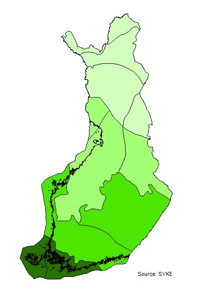
Suomi ulottuu pohjois-etelä suunnassa läpi boreaalisen havumetsävyöhykkeen. Se jaetaan neljään alavyöhykkeeseen, joiden rajat määräytyvät lämpöilmastosta aiheutuvien kasvillisuuserojen perusteella. Alavyöhykkeet jaetaan edelleen lähinnä ilmaston mereisyydestä ja mantereisuudesta johtuvien kasvillisuuserojen määräämiin lohkoihin.
Aineisto pohjautuu YM:n muistiosta nro 3/1994 Suomen metsäluonnon monimuotoisuuden kuvaaminen digitoituun aineistoon, jota on muutettu uhanalaisuusarviointien tarpeisiin kuvaruutudigitointina eri tausta-aineistoja käyttäen. Aineisto kuuluu SYKEn avoimiin aineistoihin (CC BY 4.0).
Aineistosta on julkaistu INSPIRE-tietotuote.
Käyttötarkoitus:
Aineistoa käytetään taustakarttojen tuottamiseen ja karkeisiin analyyseihin.
Finland extends through the boreal coniferous forest zone. It is divided into sub-zones and blocks determined by vegetation differences due to the maritime and continental climate.
The dataset is based on the Ministry of the Environment's Memorandum No. 3/1994. It has been modified for the needs of assessment of threatened habitat types in Finland.
The material is used for background maps and overall analyzes.
This Syke’s dataset can be used according to open data license (CC BY 4.0).
INSPIRE compatible dataset has been published.
Simple
Identification info
- Title
-
Metsäkasvillisuusvyöhykkeet
- Date (Publication)
- 2015-05-12
- Point of contact
-
Organisation name Electronic mail address Role Suomen ympäristökeskus
Owner
-
INSPIRE priority data set
- Spatial scope
-
- National
-
SYKE resource classification
-
-
Paikkatietoaineisto
-
- Keywords
-
-
INSPIRE-tietotuote
-
- Keywords
-
-
Kasvillisuus
-
metsä
-
biomaantieteelliset alueet
-
-
High-value dataset categories
-
-
Maan havainnointi ja ympäristö
-
-
EU legislation
-
-
Arvokkaat tietoaineistot
-
INSPIRE
-
Resource constraints
- Use constraints
- Other restrictions
- Other constraints
-
Creative Commons Nimeä 4.0 Kansainvälinen https://www.syke.fi/fi/ymparistotieto/kayttolupa-ja-vastuut
Lähde: Syke
- Access constraints
- Other restrictions
- Other constraints
- no limitations
- Spatial representation type
- Vector
- Denominator
- 1000000
- Metadata language
- Finnish
- Topic category
-
- Biota
Temporal extent
Spatial extent information
))
- Distribution format
-
- ESRI Shape ( 3.x)
-
GML
(
3.2.1)
- Specification
-
D2.8.III.17 Data Specification on Bio-geographical Regions – Technical Guidelines
- OGC WMS ( 1.3.0)
- OGC WFS ( 2.0.0.)
Digital transfer options
- OnLine resource
-
Protocol Linkage Name https://wwwd3.ymparisto.fi/d3/gis_data/spesific/metsakasv_vyoh.zip Syken Avoin tieto -palvelu
http://wwwd3.ymparisto.fi/d3/INSPIREAtom/BR_metsakasvillisuusvyohykkeet.xml Syken INSPIRE ATOM-syöte
https://paikkatiedot.ymparisto.fi/geoserver/inspire_br/wms?service=WMS&version=1.3.0&request=GetCapabilities EliomaantieteellisetAlueet INSPIRE WMS-katselupalvelu
https://paikkatiedot.ymparisto.fi/geoserver/inspire_br/wfs EliomaantieteellisetAlueet WFS-latauspalvelu
- Hierarchy level
- Dataset
Conformance result
- Date (Publication)
- 2010-12-08
- Explanation
-
Tietotuotemäärittelyt Inspire-direktiivin mukaisten paikkatietotuotteiden osalta.
- Pass
- Yes
- Statement
-
Suomen rajat pohjautuvat Maanmittauslaitoksen avoimien aineistojen kuntajakoon 1:100 000, 2013, johon on Sykessä lisätty merenrantaviiva ja suurimmat Itämeren saaret Syken omasta rantaviiva-aineistosta. Käyttö aineiston tarkkuuden puitteissa.
Metadata
- File identifier
- {664BE696-C6A5-4FC4-8D6A-7D2E63D0E9C6} XML
- Metadata language
- Finnish
- Character set
- UTF8
- Hierarchy level
- Dataset
- Date stamp
- 2026-03-06
- Metadata standard name
-
ISO 19115
- Metadata standard version
-
2003/Cor.1:2006
- Metadata author
-
Organisation name Electronic mail address Role Suomen ympäristökeskus
Point of contact
)))
