 Syken metatietopalvelu
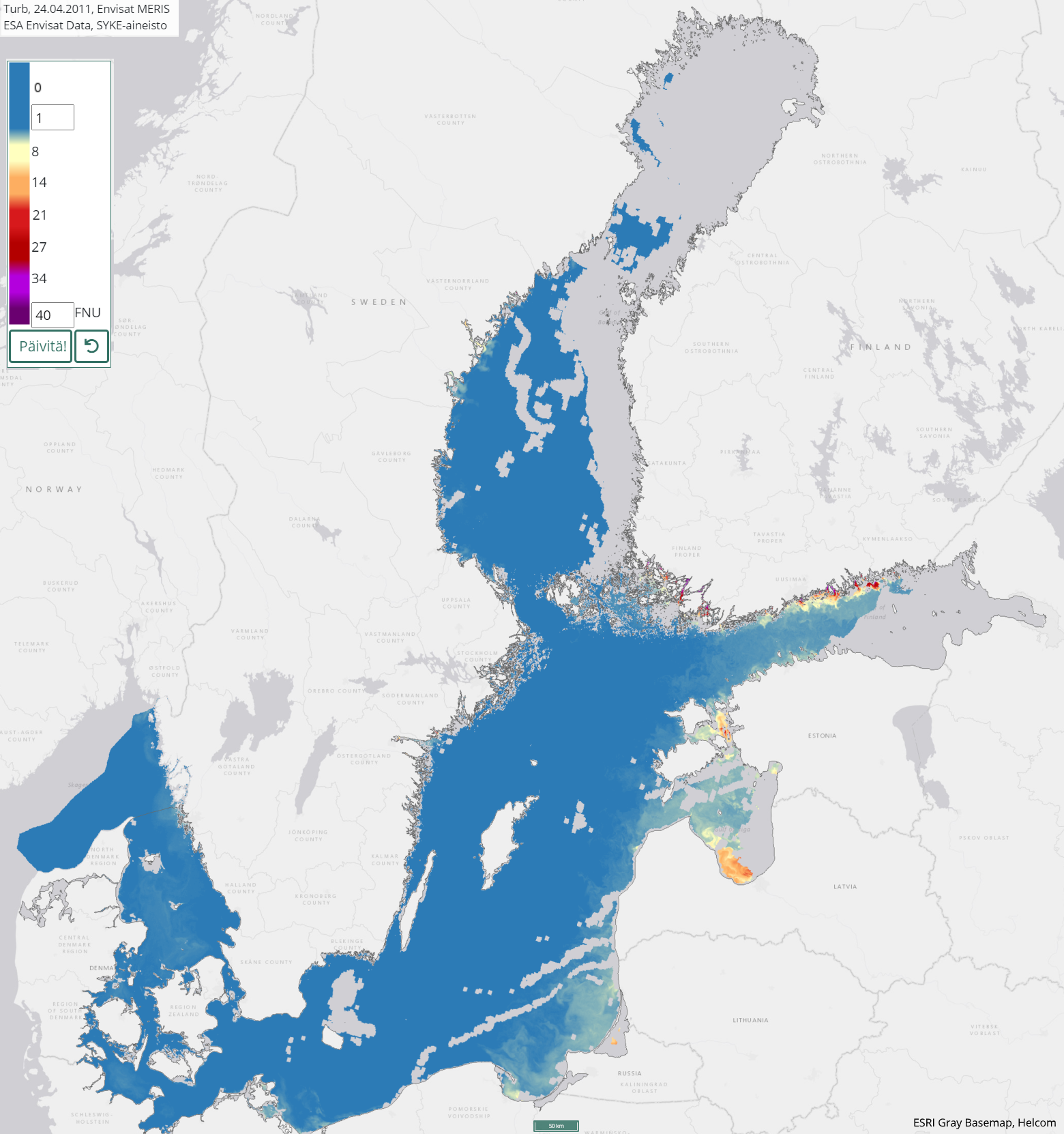
Itämeren päivittäinen sameusaineisto (Envisat MERIS) 2003–2011 / Daily turbidity of the Baltic Sea (Envisat MERIS) 2003–2011
[FI] Satelliittikuvilta seurataan Itämeren veden sameutta jäättömiltä ja pilvettömiltä alueilta huhtikuusta lokakuuhun.
Veden sameus koostuu vedessä olevista pienistä hiukkasista (kasviplankton, mineraalit tai kuollut orgaaninen aines). Sameuden määrä on laskettu Envisat MERIS (Medium Resolution Imaging Spectrometer) -instrumentin 3rd Reprocessing -datasta käyttäen C2R (Case 2 Regional) -vedenlaatuprosessoria. Aineisto koostuu vuosien 2003-2011 päivittäisistä havainnoista. Aineiston maastoerotuskyky on 300 metriä.
Kuvamuotoinen aineisto on saatavilla EO-rajapinnoilla sekä Tarkka-palvelussa, aineistosta lasketut alueelliset tilastot löytyvät STATUS-palvelusta.
Aineiston käyttötarkoitus: Itämeren vedenlaadun seuranta.
Aineisto kuuluu SYKEn avoimiin aineistoihin (CC BY 4.0).
***
[EN] Satellite remote sensing is used to monitor turbidity of surface water in the Baltic Sea during the open water season from April to October. Areas covered by ice or cloud are excluded from the data.
Turbidity represents the clarity of the water. Turbidity is caused by phytoplankton, minerals or dead organic matter in water. A daily turbidity product have been calculated using Envisat MERIS (Medium Resolution Imaging Spectrometer) 3rd Reprocessing data. Satellite data have been processed to turbidity values using C2R (Case 2 Regional) algorithm. The dataset covers years 2003-2011. The spatial resolution is 300 meters.
The imagery data is accessible via the EO interface and the Tarkka service. Regional statistics, derived from this data, can be obtained from the STATUS service.
Purpose of use: Monitoring of water quality in the Baltic Sea.
***
WMS-palvelin / WMS service endpoint: https://geoserver2.ymparisto.fi/geoserver/eo/wms
WMS-taso / WMS layer: MER_FSG_L3_rp2017_turb
Simple
Identification info
- Title
-
Itämeren päivittäinen sameusaineisto (Envisat MERIS) 2003–2011 / Daily turbidity of the Baltic Sea (Envisat MERIS) 2003–2011
- Date (Revision)
- 2017-06-26
- Point of contact
-
Organisation name Electronic mail address Role Suomen ympäristökeskus / Finnish Environment Institute (Syke)
Point of contact
-
SYKE resource classification
-
-
Satelliittihavaintotieto
-
- Keywords
-
-
Ei-Inspire
-
status assessment
-
TARKKA
-
STATUS
-
Resource constraints
- Use constraints
- Other restrictions
- Other constraints
-
[FI] Syke on mainittava lähteenä, jos tuotteita käytetään julkaisuissa tai esityksissä tai saatetaan muulla tavoin yleisön saataviin.
Envisat MERIS -aineistoihin perustuva sameus: "Syke-aineisto, alkuperäinen data Euroopan avaruusjärjestö (vuosi)"
Lisätietoja: https://wwwi4.ymparisto.fi/i4/fin/eowiki/aineistojen_kayttoluvat.html
***
[EN] Syke must be cited as a source if the products are used in publications or performances or otherwise made available to the public.
Turbidity based on Envisat MERIS data: "Syke data, original data provided by the European Space Agency (year)
More info: https://wwwi4.ymparisto.fi/i4/eng/eowiki/license_information.html
- Access constraints
- Other restrictions
- Other constraints
- no limitations
- Spatial representation type
- Grid
- Metadata language
- English
- Topic category
-
- Environment
- Oceans
Temporal extent
Spatial extent information
))
- Unique resource identifier
- EPSG:4326
- Codespace
-
EPSG
- Distribution format
-
- GeoTiff ( -)
Digital transfer options
- OnLine resource
-
Protocol Linkage Name https://www.syke.fi/tarkka Tarkka-palvelu/service
https://geoserver2.ymparisto.fi/geoserver/eo/ows?service=wms&version=1.3.0&request=GetCapabilities GetCapabilities-dokumentti
https://geoserver2.ymparisto.fi/geoserver/eo/wms?SERVICE=WMS&VERSION=1.1.1&REQUEST=GetMap&FORMAT=image%2Fpng&TRANSPARENT=true&tiled=true&STYLES=&LAYERS=MER_FSG_L3_rp2017_turb&TIME=2011-05-18&WIDTH=256&HEIGHT=256&SRS=EPSG%3A3857&BBOX=2191602.4749925733%2C8922952.933898335%2C2348145.508920614%2C9079495.967826376 WMS-esimerkki / WMS example
https://wwwi4.ymparisto.fi/i4/fin/eowiki/aineistot_aineistot.html Lisätietoa Syken EOwikissä
https://wwwi4.ymparisto.fi/i4/eng/eowiki/datasets_start.html More information in Syke's EOwiki
https://www.syke.fi/fi/ymparistotieto/avoimet-rajapinnat/satelliittihavaintojen-rajapinnat Satelliittihavaintojen rajapinnat/EO web map services
- Hierarchy level
- Series
- Statement
-
[FI] Kaukokartoitusseurantojen tuloksena syntynyt vuosien 2003–2011 havainnoista koostuva päivittäinen sameusaineisto.
Prosessointihistoria:
Sameus on tulkittu Envisat MERIS-satelliitti-instrumentin 3rd Reprocessing aineistoilta. Alkuperäinen satelliittidata on ladattu Euroopan avaruusjärjestön (ESA) latauspalveluista. Sykessä niistä on laskettu sameustulkinnat käyttäen C2R (Case 2 Regional) -vedenlaatuprosessoria.
[EN] Turbidity data from years 2003–2011 for the Baltic Sea.
Processing history:
The Envisat MERIS 3rd Reprocessing data have been received from ESA service. The dataset has been processed to turbidity values in Syke using the C2R algorithm (Case 2 Regional), which includes atmospheric correction. A quality check have been performed for every daily image.
Metadata
- File identifier
- {5241F4C8-1F05-4AF0-9A0C-677EBA6BD4A6} XML
- Metadata language
- Finnish
- Character set
- UTF8
- Hierarchy level
- Series
- Date stamp
- 2026-11-19T11:41:23.391048Z
- Metadata standard name
-
ISO 19115
- Metadata standard version
-
2003/Cor.1:2006
- Metadata author
-
Organisation name Electronic mail address Role Suomen ympäristökeskus / Finnish Environment Institute (Syke)
Point of contact
Overviews
Spatial extent
)))
Provided by
