 Syken metatietopalvelu
Itämeren vuosittainen leväkooste (Sentinel-3, Sentinel-2 & Landsat-8/9) 2017– / Yearly algae composites of the Baltic Sea (Sentinel-3, Sentinel-2 & Landsat-8/9) 2017–
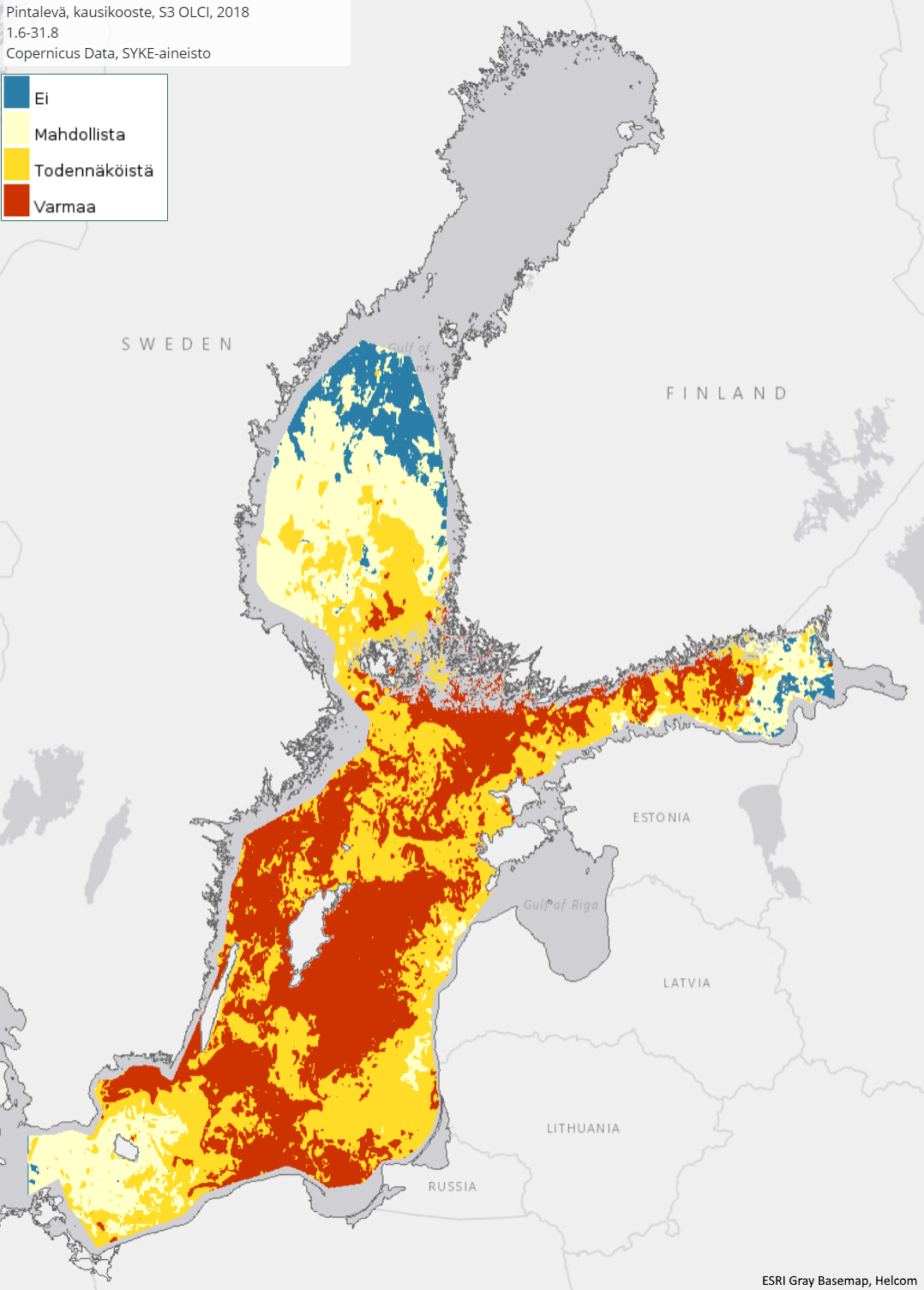
[FI] Vuosittainen Itämeren avomerialueen pintaleväkooste yhdistetään kesäkauden päivittäisistä havainnoista. Tämä kuvaus kattaa aineistot vuodesta 2017 eteenpäin. Pintalevälautoista tehdään neliluokkainen tulkintakartta, joka kuvaa pintalevän esiintymistodennäköisyyttä tietyllä alueella. Kartan luokat ovat 1) ei pintalevää, 2) mahdollista, 3) todennäköistä sekä 4) varmaa pintalevää. Kooste kuvaa suurinta havaittua levän määrää kesä-elokuun aikana kullakin alueella. Vuosittainen kooste kokoaa yhteen Itämeren pääaltaan, Selkämeren ja Suomenlahden pintalevähavainnot kesä-elokuun ajalta.
Koosteet vuodesta 2018 alkaen ovat ~0,003° maastoerotuskyvyllä (n. 370 m × 180 m). Vuoden 2017 kooste on karkeammalla maastoerotuskyvyllä (0,009°, n. 1 000 m × 500 m).
Päivittäiset pintalevähavainnot perustuvat Sentinel-3 OLCI-satelliitti-instrumentin eri aallonpituusalueiden havaitseman veden pintakerroksesta lähtevän heijastuksen voimakkuuteen, joka on sinileväalueilla erilainen kuin levättömillä vesialueilla. Vuodesta 2020 alkaen koosteeseen on otettu mukaan myös Sentinel-2 MSI-satelliitti-instrumentin havainnot, joten aineisto kattaa tarkemmin myös rannikon läheiset alueet. Vuodesta 2022 alkaen koostetta on täydennetty myös Landsat-8- ja Landsat-9-satelliittien OLI- ja OLI-2-instrumenttien aineistoista tehdyillä levälauttatulkinnoilla.
Aineiston käyttötarkoitus: Itämeren vedenlaadun seuranta, levätiedotus.
Aineisto kuuluu SYKEn avoimiin aineistoihin (CC BY 4.0).
***
[EN] The annual composite of phytoplankton surface blooms are made from daily surface algal bloom observations during the summer period. The algal observations are converted into a four-class interpretation map representing the probability of the occurrence of surface algal blooms in a particular area. The algal classes are (1) No, (2) Potential, (3) Likely, and (4) Evident surface algae. Seasonal composites represent the maximal state of the algae blooms from June to August. The composites since 2018 are at ground resolution of ~0.003° (approx. 370 m × 180 m). The composite of 2017 is of coarser ground resolution (0.009°, approx. 1,000 m × 500 m).
Surface algae bloom areas can be separated from non-algal areas based on the reflectance observed by the Sentinel-3 satellite series OLCI-instrument. The method uses various wavelength bands observed by the satellite, which differ between cyanobacterial areas and areas without cyanobacteria. Since 2020, the composite has also included material from the Sentinel-2 MSI satellite instrument. Starting in 2022, the composite has also been supplemented with interpretations made from data from the OLI and OLI-2 instruments of the Landsat-8 and Landsat-9 satellites. This allows the dataset to cover the areas closer to shoreline better.
Purpose of use: Monitoring of water quality in the Baltic Sea, algal watch.
***
WMS-palvelin / WMS service endpoint: https://geoserver2.ymparisto.fi/geoserver/eo/wms
WMS-taso / WMS layer, (vuodet aineistossa/years in data 2017 -> ): eo:EO_SEASONAL_ALGAE
***
Simple
Identification info
- Title
-
Itämeren vuosittainen leväkooste (Sentinel-3, Sentinel-2 & Landsat-8/9) 2017– / Yearly algae composites of the Baltic Sea (Sentinel-3, Sentinel-2 & Landsat-8/9) 2017–
- Date (Publication)
- 2018-11-05
- Point of contact
-
Organisation name Electronic mail address Role Suomen ympäristökeskus / Finnish Enviroment Institute (Syke)
Point of contact
-
SYKE resource classification
-
-
Satelliittihavaintotieto
-
- Keywords
-
-
Ei-Inspire
-
TARKKA
-
status assessment
-
FEO
-
Resource constraints
- Use constraints
- Other restrictions
- Other constraints
-
Creative Commons Nimeä 4.0 Kansainvälinen
***
[FI] Syke on mainittava lähteenä, jos tuotteita käytetään julkaisuissa tai esityksissä tai saatetaan muulla tavoin yleisön saataviin.
Sentinel-3, Sentinel-2 ja Landsat-8/9 -aineistoihin perustuva pintalevä: "Syke-aineisto, sisältää muokattua Copernicus ja USGS/NASA Landsat program -dataa (vuosi)"
Lisätietoja: https://wwwi4.ymparisto.fi/i4/fin/eowiki/aineistojen_kayttoluvat.html
***
[EN] Syke must be cited as a source if the products are used in publications or performances or otherwise made available to the public.
Algae composite based on Sentinel-3, Sentinel-2 and Landsat-8/9 data: "Syke data, contains modified Copernicus and USGS/NASA Landsat program -data (year)"
More info: https://wwwi4.ymparisto.fi/i4/eng/eowiki/license_information.html
- Access constraints
- Other restrictions
- Other constraints
- no limitations
- Spatial representation type
- Grid
- Metadata language
- English
- Topic category
-
- Environment
- Oceans
Temporal extent
- Begin
- 2017
Spatial extent information
))
- Unique resource identifier
- EPSG:4326
- Codespace
-
EPSG
- Distribution format
-
- GeoTiff ( -)
Digital transfer options
- OnLine resource
-
Protocol Linkage Name https://tarkka.syke.fi Tarkka-palvelu/service
https://geoserver2.ymparisto.fi/geoserver/eo/ows?service=wms&version=1.3.0&request=GetCapabilities GetCapabilities-dokumentti
https://geoserver2.ymparisto.fi/geoserver/eo/wms?service=WMS&version=1.1.0&request=GetMap&layers=eo:EO_SEASONAL_ALGAE&TIME=2023&styles=&bbox=14.6875,53.991,30.8125,66.006&width=768&height=572&srs=EPSG:4326&format=image%2Fpng%3B%20mode%3D8bit WMS-esimerkki / WMS example
https://wwwi4.ymparisto.fi/i4/fin/eowiki/aineistot_aineistot.html Lisätietoa Syken EOwikissä
https://wwwi4.ymparisto.fi/i4/eng/eowiki/datasets_start.html More information in Syke's EOwiki
https://www.syke.fi/fi/ymparistotieto/avoimet-rajapinnat/satelliittihavaintojen-rajapinnat Satelliittihavaintojen rajapinnat/EO web map services
- Hierarchy level
- Series
- Statement
-
[FI] Koosteet on laskettu kesäkauden Sentinel-3 OLCI, Sentinel-2 ja Landsat8/9 pintalevähavainnoista.
***
[EN] Composites have been calculated from surface algae observations of the Sentinel-3 OLCI, Sentinel-2 and Landsat-8/9 for the summer season.
Metadata
- File identifier
- {42D63482-350E-4149-8606-145AFFC0E388} XML
- Metadata language
- Finnish
- Character set
- UTF8
- Hierarchy level
- Series
- Date stamp
- 2026-11-18T12:56:35.448131Z
- Metadata standard name
-
ISO19115
- Metadata standard version
-
2003/Cor.1:2006
- Metadata author
-
Organisation name Electronic mail address Role Suomen ympäristökeskus / Finnish Enviroment Institute (Syke)
Point of contact
)))
