 Syken metatietopalvelu
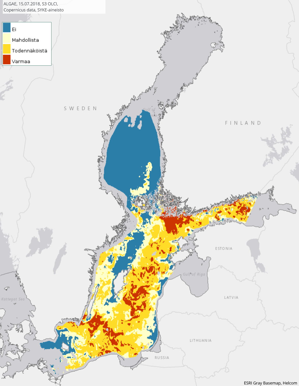
Itämeren päivittäinen pintaleväaineisto (Sentinel-3 OLCI) 2017– / Daily surface algae blooms of the Baltic Sea (Sentinel-3 OLCI) 2017–
[FI] Itämeren alueen ja erityisesti Suomea ympäröivien merialueiden pintalevälauttoja kuvaava neliluokkainen tulkintakartta. Tulkintakartta kuvaa todennäköisyyttä, että tietyllä alueella esiintyy pintalevää. Kartan luokat ovat 1) ei pintalevää, 2) mahdollista, 3) todennäköistä sekä 4) varmaa pintalevää. Pintalevää ei kyetä havainnoimaan optisilla satelliitti-instrumeneilla pilvien läpi, joten pintaleväkartta puuttuu pilvisiltä alueilta.
Tulkintoja tehdään kesäkuun lopulta syyskuun alkuun, tarvittaessa pidempäänkin. Pääasiassa levälauttoja esiintyy eniten heinä-elokuussa, joten kyseiseltä ajanjaksolta pintalevähavaintojen määrä on suurin. Tulkintamenetelmä perustuu satelliitin eri aallonpituusalueiden havaitseman heijastuksen voimakkuuteen, joka on sinileväalueilla erilainen kuin levättömillä vesialueilla. Yksittäisten pikselien alueelta tehty pintalevätulkinta yleistetään karkeammaksi, jotta kartalla näkyvät leväalueet ovat selkeämmät. Kartta-alueelta poistetaan pilviset alueet automaattisella pilventunnistusmenetelmällä, jota täydennetään tarvittaessa ennen julkaisua myös manuaalisesti.
Tulkintamenetelmä on kehitetty Sykessä ja se hyödyntää eri satelliitti-instrumentin havaintoja. Tämä aineisto koostuu ESAn Copernicus-ohjelman Sentinel-3 -satelliittisarjan OLCI-instrumenttin havainnoista vuodesta 2017 lähtien. OLCI havainnoi 300 m maastoerotuskyvyllä.
Aineistoista tehdään vuosittainen koostekartta levätiedotuksen tarpeisiin (erillinen meta).
Aineisto kuuluu SYKEn avoimiin aineistoihin (CC BY 4.0).
***
[EN] A four-class interpretation map describing surface floating algae blooms in the Baltic Sea region and especially in the sea areas surrounding Finland. The interpretation map describes the probability that surface algae will occur in a particular area. The map categories are 1) No, 2) Potential, 3) Likely, and 4) Evident surface algae. Surface algae cannot be detected by optical satellite instruments through clouds, so a map of surface algae is missing from cloudy areas.
Interpretations will be made from late June to early September, and longer if necessary. Algae bloom mainly occur most in July-August, so the number of surface algae observations is the highest during that period. The interpretation method is based on the intensity of the reflection detected by the different wavelength ranges of the satellite, which is different in cyanobacterial areas than in restless waters. A surface algae interpretation made from the area of individual pixels is generalized to a rougher one so that the areas of algae displayed on the map are clearer. Cloudy areas are removed from the map area by an automatic cloud detection method, which is also completed manually before publication, if necessary.
The interpretation method has been developed at Syke and utilizes the observations of various satellite instruments. This data is based on the OLCI instrument (OLCI) of the Sentinel-3 satellite series of ESA's Copernicus program starting from year 2017. OLCI observes in 300 m terrain resolution.
An annual summary map of the data is made for the needs of Syke's algae bloom monitoring (separate metadata).
***
WMS-palvelin / WMS service endpoint: https://geoserver2.ymparisto.fi/geoserver/eo/wms
WMS-taso / WMS layer: EO_MR_OLCI_ALGAE
Simple
Identification info
- Title
-
Itämeren päivittäinen pintaleväaineisto (Sentinel-3 OLCI) 2017– / Daily surface algae blooms of the Baltic Sea (Sentinel-3 OLCI) 2017–
- Date (Publication)
- 2017-07-07
- Point of contact
-
Organisation name Electronic mail address Role Suomen ympäristökeskus / Finnish Environment Institute (Syke)
Point of contact
-
SYKE resource classification
-
-
Satelliittihavaintotieto
-
- Keywords
-
-
Ei-Inspire
-
status assessment
-
TARKKA
-
STATUS
-
Meriopas
-
Seaguide
-
Resource constraints
- Use constraints
- Other restrictions
- Other constraints
-
Creative Commons Nimeä 4.0 Kansainvälinen
[FI] Syke on mainittava lähteenä, jos tuotteita käytetään julkaisuissa tai esityksissä tai saatetaan muulla tavoin yleisön saataviin.
Sentinel-3-aineistoihin perustuva pintalevä: "Syke-aineisto, sisältää muokattua Copernicus-dataa (vuosi)"
Lisätietoja: https://wwwi4.ymparisto.fi/i4/fin/eowiki/aineistojen_kayttoluvat.html
***
[EN] Syke must be cited as a source if the products are used in publications or performances or otherwise made available to the public.
Surface algae based on Sentinel-3 data: "Syke data, contains modified Copernicus data (year)"
More info: https://wwwi4.ymparisto.fi/i4/eng/eowiki/license_information.html
***
- Access constraints
- Other restrictions
- Other constraints
- no limitations
- Spatial representation type
- Grid
- Metadata language
- English
- Topic category
-
- Environment
- Oceans
Temporal extent
- Begin
- 2017
Spatial extent information
))
- Unique resource identifier
- EPSG:4326
- Codespace
-
EPSG
- Distribution format
-
- GeoTiff ( -)
Digital transfer options
- OnLine resource
-
Protocol Linkage Name https://www.syke.fi/tarkka Tarkka-palvelu/service
https://meriopas.ymparisto.fi/meriopas Meriopas / Seaguide
https://geoserver2.ymparisto.fi/geoserver/eo/ows?service=wms&version=1.3.0&request=GetCapabilities GetCapabilities-dokumentti
https://geoserver2.ymparisto.fi/geoserver/eo/wms?service=WMS&version=1.1.0&request=GetMap&layers=eo:EO_MR_OLCI_ALGAE&bbox=13.5231764283148,54.3568091987064,28.8519583183615,63.2446999640676&time=2019-07-25&width=768&height=445&srs=EPSG:4326&format=image/png WMS-esimerkki / WMS example
https://wwwi4.ymparisto.fi/i4/fin/eowiki/aineistot_aineistot.html Lisätietoa Syken EOwikissä
https://wwwi4.ymparisto.fi/i4/eng/eowiki/datasets_start.html More information in Syke's EOwiki
https://www.syke.fi/fi/ymparistotieto/avoimet-rajapinnat/satelliittihavaintojen-rajapinnat Satelliittihavaintojen rajapinnat/EO web map services
- Hierarchy level
- Series
- Statement
-
[FI] Kaukokartoitusseurantojen tuloksena syntynyt levälauttatulkinta, joka pohjautuu Sentinel-3 OLCI -satelliittihavaintoihin. Vuodesta 2017 eteenpäin koostuva päivittäinen levälautta-aineisto.
Prosessointihistoria:
Levälautat on tulkittu Sentinel-3 OLCI-satelliitti-instrumentin aineistoilta. Alkuperäinen satelliittidata on ladattu Euroopan avaruusjärjestön (ESA) latauspalveluista. Sykessä niistä on laskettu levätulkinnat.
Metadata
- File identifier
- {4094A643-A56B-4FDA-A8F4-F5C586EA8E42} XML
- Metadata language
- Finnish
- Character set
- UTF8
- Hierarchy level
- Series
- Date stamp
- 2026-11-18T11:44:36.024332Z
- Metadata standard name
-
ISO19115
- Metadata standard version
-
2003/Cor.1:2006
- Metadata author
-
Organisation name Electronic mail address Role Suomen ympäristökeskus / Finnish Environment Institute (Syke)
Point of contact
)))
